Congress Program

A roadmap to multifunctional and resilient landscapes: the adaptation to global change through Blue and Green Infrastructure Networks (BGINs)

DAY 1 – MARCH 16, 2021

HOUR
CET,UTC+1

TITLE

SPEAKER

10:00 – 10:15

Fisheries, tourism, agriculture and forestry provide essential economic goods (ecosystem services, ES) for the development of many coastal and rural areas within the Atlantic region. All landscapes, including the mountainous, plateau and coastal landscapes found within the Atlantic region can provide multiple ES. However, delivery of ES can be affected by a loss of biodiversity which can impair ecosystem functioning. Land use and climate changes can have deleterious impacts on biodiversity and therefore affect the delivery of ES in these Atlantic landscapes. Aquatic ecosystems (from rivers to estuaries) are especially vulnerable to such impacts, as they are the final receptors of human activities in the catchment such as urbanization in coastal areas, riparian clearance, over application of fertilisers, poor soil management or overgrazing. Thus, an integrative landscape management approach is critical for the sustainable development of the Atlantic area, ensuring the conservation of biodiversity and the delivery of ES.

Blue and Green Infrastructure Networks (BGINs) are being promoted across the world in order to restore and improve biodiversity and enhance ES. However, the implementation of BGINs requires that land-managers develop a full understanding of how to direct public and private investment. Thus, there is an urgent need for tools to identify and deliver the benefits from BGINs to different stakeholders across the Atlantic Region and beyond. In this talk, we introduce the innovative and integrative technological approach developed by ALICE which consists of: (1) Identify the benefits -the ES delivered by BGINs by (a) combining a range of satellite images, GIS data and modelling frameworks to map aquatic and terrestrial vegetation formations, (b) enhance the predictive capacity by using a multi-model platform and (c) the use of participatory learning processes to engage local stakeholders, and (2) explore the economic and social barriers to the delivery of ES.

Jose Barquín Ortiz, Instituto de Hidráulica Ambiental ‘IHCantabria’, SPAIN

10:15 – 10:30

The Green and Blue Network policy (2007) aims at producing ecological networks from the national to the local (municipality) scales. The concept is to define networks at all scales, which concern different species some moving across regions, others over a few hectares.

In the WOODNET project, we tackled the landscape mapping and network modeling issues, which differ according to species mobility. We also show that landscape permeability requires a multiscale landscape analysis, not only patch to patch quality is important, but the surroundings, from a few hundred meters to a few kilometers, also matter.

Jacques Baudry, BAGAP, INRAE, Institut Agro, ESA, 35042, Rennes, FRANCE

Session 1 – Towards an intelligent landscape management: understanding the evolution of ecosystems

10:30 – 10:45

Anticipating future landscape changes is an innovative approach to evaluate the efficiency of land use policies. The ALICE project used an adaptative approach as Atlantic countries are more or less advanced in BGINs design and implementation.

For those unused with BGINs, we compared “Business-us-usual” scenarios with and without BGINs to explore the interest of such a policy. For those already engaged in BGINs implementation, we compared contrasted scenarios of future Land use and cover changes (LUCC) to evaluate its efficiency across various socio-economic futures.

For all cases, we developed and used a LUCC model to simulate future landscape changes at a fine scale in order to evaluate their possible environmental impacts in the future. Thanks to the knowledge provided by scenarios on what could happen, this should help decision makers to implement more sustainable and efficient land policies than they would have done without this knowledge.

Thomas Houet, CNRS – UMR LETG 6554, Université Rennes 2, FRANCE

10:45 – 11:00

A current challenge of biodiversity and conservation is the estimation of the spatial extent and conservation status of habitat types across broad territories. In the absence of fine-resolution maps, predictive modelling helps assessing the distribution and major trains of vegetation types across space and through time.

A framework for mapping the area of occupancy (AOO) of habitat types has been applied across ALICE case studies, using a combination of remote sensing based modelling and in situ vegetation surveys. Habitat mapping is a methodological key skill in modern environmental research that capitalizes ecological modelling developments for the assessment of vegetation patterns, processes and dynamics.

Ecological models are very useful for simulating and analyzing the long-term dynamics and stability properties of complex ecological systems across broad territories. Moreover, model results can be coupled to scenarios of LULCC in order to compare and rank the distribution of biodiversity and ecosystem functions major environmental constrains in face of Global Change, including both climate warming and land use changes.

Jose Manuel Álvarez-Martínez, Instituto de Hidráulica Ambiental ‘IHCantabria’, SPAIN

11:00 – 11:15

Assessing the effect of scenarios of LULCC on biodiversity needs proxies, available at large scale and fine resolution on territories.

We used habitat types in ALICE case studies as they are assumed to reflect potential biodiversity occurring in ecosystems.

We analyzed in the French Case study how landscape structure affects biodiversity taking plants as an example, and using real data for two given habitat types – permanent grasslands and hedgerows – that are both of ecological interest and present across a range of landscape structure types in the case study.

Through a large-scale experimental design based on 30 landscape sites and including more than 50 farmers, we analyzed the effect of landscape structure and climate on grassland and hedgerow biodiversity. We demonstrated that a given category of habitat type covers a range of biodiversity patterns in plants. While species biodiversity was not sensitive to landscape nor climate variables, functional biodiversity did respond to the habitat amount and landscape configuration and/or composition.

Landscape-induced changes in functional biodiversity ultimately affect productivity in grasslands.

These results suggest that habitat type may reflect biodiversity in plants, but should be completed by functional indices that might respond to land use changes and be related to modification in key ecological functions of ecosystems. Combining functional indices to habitat mapping might then be a promising avenue for further proxy development.

Cendrine Mony, University of Rennes 1, FRANCE

11:15 – 11:30

The use of model ensembles is highly recommended in order to take due account of the uncertainties associated with the design and parameterization of physical-mathematical climate models. For this reason, 5 pairs of regional climate models (RCMs) are coupled to global climate models (GCM), which allows a significant reduction of scale and a consequent increase in spatial resolution of the datasets.

These data were produced under the EURO-CORDEX project. The data were subject to a bias correction performed under the previous project (SMHI-DBS45-MESAN, 1989-2010). The final data presents a spatial resolution of 1 km in all variables, temperature (mean, minimum and maximum) and precipitation, for all case studies. Further, the new databases served as input to SPHY hydrological model to simulate historical and future flowrates.

André Fonseca, CITAB Universidade de Trás-os-Montes e Alto Douro, PORTUGAL

11:30 – 11:45

Coffee Break

Session 2 – Towards an intelligent landscape management: ecosystem service modelling

11:45 – 11:55

This talk describes the adaptation of a non-spatial model of pastureland dynamics, including vegetation life cycle, livestock management and nitrogen cycle, for use in a spatially explicit and modular modelling platform (k.LAB) dedicated to make data and models more interoperable.

The aim is to deliver an existing, locally successful monolithic model, into a more modular, transparent and accessible approach to potential end users, regional managers, farmers and other stakeholders. This allows better usability and adaptability of the model beyond its originally intended geographical scope (the Cantabrian Region in the North of Spain).

The original model, named Puerto, is developed in the R language and includes 1,491 lines of code divided into 13 script files and linked to 19 input tables. The spatiotemporal rewrite is structured around a set of 10 namespaces called PaL (Pasture and Livestock), which includes 198 interoperable but independent models.

The end user chooses the spatial and temporal context of the analysis through an intuitive web-based user interface called k.Explorer. Each model can be called individually or in conjunction with the others, by querying any PaL-related concepts in a search bar.

A scientific workflow is built as a response, which is run to produce result datasets and a report with information on the data sources and modelling processes used, delivering results with full transparency.

We argue that this work demonstrates key steps needed to create more Findable, Accessible, Interoperable and Reusable (FAIR) models. This is particularly essential in environments as complex as agricultural systems, where multidisciplinary knowledge needs to be integrated across diverse spatial and temporal scales in order to understand complex and changing problems.

Alba Márquez Torres, Basque Centre for Climate Change, SPAIN

11:55 – 12:05

Water quality and fish biomass are key components of several provisioning and regulating ecosystems services which are highly influence by climatic and land cover variables. In order to estimate the changes in water quality and fish biomass taking into account different simulation scenarios, a multi-model approach framework has been applied across ALICE case studies.

Models results are very useful for understanding the potential changes produced by global change or the implementation of Blue-Green Infrastructure Networks (BGINs) on aquatic ecosystems which is essential for their conservation and management.

Alexia María González-Ferreras, Instituto de Hidráulica Ambiental ‘IHCantabria’, SPAIN

12:05 – 12:20

Blue and green infrastructure networks (BGINs) have the potential to increase the resilience of ecosystems and human societies in the face of global environmental change. However, they are not a panacea either and their implementation might imply advantages and disadvantages: identifying such trade-offs is key.

To plan smartly it is necessary to adopt a complexity embracing an approach that considers both the effects on ecological dynamics at multiple scales and on human-related values for different stakeholders’ groups. Thus, intelligent planning implies the maximization of positive consequences and the limitation of the negative ones according to multidimensional perspectives.

To estimate the expected consequences before implementation (ex-ante) it is necessary to employ simulation models of different components of the combined social-ecological system and to integrate them in a coherent simulation framework. To understand their implications in the coming years, it is paramount to consider the expected trends in land use and cover change and in key ecological and climatic variables, also delivered through ad-hoc simulation models.

Further, to secure acceptability and fairness across different stakeholders, it is fundamental to engage different stakeholders groups since the beginning of the planning process: this is key to foster the co-creation, validation and ownership of the knowledge generated.

Ferdinando Villa & Stefano Balbi, Basque Centre for Climate Change, Bilbao SPAIN

12:20 – 12:35

Traditionally, worldwide policies of forest recover have focused on maximising timber production and carbon sequestration, generating trade-offs with regulating ecosystem services and reducing the ability of afforestation to response adequately to multiple goals.

New actions should be integrated into broader spatial planning instruments, such as Blue Green Infrastructure Networks (BGINs) schemes (planned network of Nature Based Solutions; NBS), in order to:

(i) optimize biodiversity and multifunctionality at the landscape scale and

(ii) control trade-offs among bundles of ES.

These approaches allow defining appropriate mechanisms to assemble active and passive restoration actions, managing a wide range of ecosystems and other alternatives in cost-effective ways that enable achieving multifunctional landscapes and ensuring biodiversity conservation under uncertain scenarios of Global Change.

Ignacio Pérez-Silos, Instituto de Hidráulica Ambiental ‘IHCantabria’, SPAIN

12:35 – 13:00

Round table: Sessions 1 & 2 discussion

Ferdinando Villa, Basque Centre for Climate Change, Bilbao SPAIN

DAY 2 – MARCH 17, 2021

HOUR
CET,UTC+1

TITLE

SPEAKER

Session 3 – Participatory learning for territory management

10:20 – 10:35

One of the key objectives of the Alice project is to stimulate the use of Blue-Green Infrastructure (BGI). BGI is being seen as a more popular means of dealing with climate change and climate change-related events. However, as the concept of BGI is relatively new, many urban and rural planners are unfamiliar with the barriers they may face during the lifecycle of a BGI project. As a result, some have been hesitant to adopt BGI solutions.

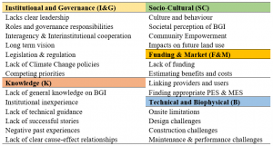
The literature has unveiled many of the barriers that inhibit the successful development of BGI. However, this information has yet to be presented in a manner that allows for easy identification. This presentation will discuss the results of a systematic literature review conducted to develop a framework which will enable BGI planners to assess the potential threats of a BGI project throughout the project’s lifecycle. The barriers identified through this research are shown in table 1.

Table 1. Barrier Identification Framework

John Deely, SEMRU, National University of Ireland Galway

10:35 – 10:50

As part of the ALICE project a number of stated preference valuation approaches were employed to assess the preferences and willingness to pay of residents in the case study areas for Blue Green Infrastructure (BGI) enhancements.

Stated preference valuation approaches are often used to estimate non-use environmental values or where choices in markets cannot be observed. They are based on constructed hypothetical markets through which individuals are asked to express their willingness to pay for environmental goods and services.

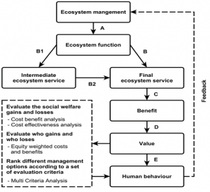
As shown in Figure 1 the valuation estimates from such studies can be used in a cost benefit analysis to determine the benefit values associated with the management of ecosystems which has the aim of delivering a suite of ecosystem services that provide benefits to society. For example the active restoration of floodplains and wetlands can reduce the prevalence of flooding events and dampen down the effects of storm surges.

These nature based solutions not only provides the ecosystem service benefits to the coastal community but can also be a more cost effective solution than alternative grey infrastructure solutions to the same problems.

Figure 1. From ecosystem management to welfare benefits[1]

In the Irish Carlingford catchment case study, whether individuals preferred a BGI solution to flooding as opposed to a grey infrastructure solution was examined using a choice experiment approach.

In the Spanish case study area of the three river basins: Pas, Miera and Asón, resident attitudes and practices related to sustainable agriculture and beef rearing in the Pasiegas Mountains area were examined. In particular a contingent valuation approach was employed to assess preferences and willingness to pay for beef production that does not use uncontrolled burning methods.

In the French case study area of the Couesnon River catchment a choice experiment was employed to estimate the willingness to pay of residents for BGINs to improve biodiversity conservation and reduce flooding and water supply shortage risks.

The results of these studies demonstrate that the residents of the case study areas would be willing to pay a premium for a BGI option and that they value the additional ecosystem service benefits that are an intrinsic quality of a BGI.

[1] Adapted from Hanley et al. (2016)

Stephen Hynes, SEMRU, National University of Ireland Galway

10:50 – 11:00

In the Carlingford Catchment, the potential providers of BGINs are farmers, with agricultural production being the dominate land-use. Agriculture is diverse across the catchment, with grazing dominating in the north west and more extensive shrublands surrounding the lough itself.

The workshops identified key issues as being water quality, water quantity (flooding) and the increasing risk of wild fires in the areas around the lough – all of which could be mitigated through the use of BGINs.

With over 1,000 farmers across the catchment, the need to get farmers engaged with BGINs and coordinating their actions is vital. This presentation reports of a qualitative study of farmers, exploring the barriers to participation within BGINs and how engagement can be enhanced.”

Dianne Burguess, Agri-Food and Biosciences Institute, Belfast, NORTHERN IRELAND

11:00 – 11:15

Johanna Ballé-Béganton, Denis Bailly, Klervi Fustec, Manuelle Philippe, Alix Levain

According to the European Commission (2012), stakeholder participation will be crucial to the success of Blue and Green Infrastructure Networks (BGIN). BGIN development calls for originality in its process and particularly for distinctive participatory assessments of nature based solution on a territory. Planning such networks must take into account the social and economical implications and possible barriers and necessary trade-offs. The process has to embrace transdisciplinarity, be imbedded in local policies and engage stakeholders at each step.

The multi-model platform developed in ALICE has been embedded in a stakeholder engagement framework that ensured pro-active interactions between scientists and stakeholders at each step of the project. Innovative landscape management has to find the right alchemy to sustain engagement while avoiding stakeholder fatigue, stay in adequacy with stakeholders needs, identify science knowledge gaps and better angle research focus, and create a dynamic discussion forum.

Based on the lessons learned from the four ALICE case studies and from former participatory assessment experiments during Interreg and H2020 European projects, we developed a methodological handbook where we explore how research has not only to span several disciplines from environmental to social sciences but interact strongly with stakeholders and empower the discipline of transdisciplinarity with creative methodologies and tools. The handbook: “Towards collaborative environmental management: Road map to a participatory assessment” will be available at the end of the ALICE project as well as a web site with tools and resources: participatory-assessment.eu.

Johanna Balle Beganton, UMR AMURE, Université de Brest, FRANCE

11:15 – 11:30

Coffee Break

Session 4 – BGINs implementation: barriers and solutions across the Atlantic area

11:30 – 11:45

Although some of the factors that currently condition the evolution of the Atlantic landscape in Cantabria are well known among scientists and citizens, ALICE has been a great opportunity to deepen and systematize their study, especially in the cases of fires, floods and erosion. BGINs had never been the subject of in-depth study in the region as part of the dialogue of the key agents of the territory. Through the participatory learning process that has been carried out throughout the project, specifically illustrated in the third workshop, it has been possible not only to adopt a common language around BGINs but also to build a bridge between science and society by involving stakeholders in the identification of “hot spots” in which it would be advisable to intervene and in the development of future scenarios. As a result, it can be affirmed that the ALICE project has undoubtedly succeeded in generating a breeding ground, both at the technical and social levels, for the future deployment of blue and green infrastructure networks in the region.

Jaime Gutiérrez Bayo, BRUMA sostenibilidad y participación ciudadana S.L
Ana Silió Calzada, Instituto de Hidráulica Ambiental ‘IHCantabria’,
SPAIN

11:45 – 12:00

Urbanization and agricultural intensification are the main drivers of biodiversity losses through multiple stressors, of which habitat fragmentation, isolation and loss are paramount. The design of Blue and Green Infrastructure Networks (BGINs) which corridors are based on the configuration of meadows and forests patches have been proposed as a potential land use planning tool to increase ecosystem service provisioning while securing biodiversity patterns. In France, BGINs policy is nowadays a mandatory land planning scheme defined by municipalities. Following a participatory framework applied on the Couesnon watershed (Brittany, France), five possible pathways of future land use and land cover changes have been designed accounting for BGINs implementation and their future landscape changes simulated: (1) the business-as-usual, (2) the “double performance”, (3) the “desert of cereals”, (4) the “green biomass” and (5) the BGINs utopia scenarios. Results show that future agricultural land uses would strongly affect long-term future ecosystems services even though these changes in the landscape may be considered as subtle. From these results, we evaluate the potential efficiency and limitations of BGINs policy, as applied in France. Barriers and leverages are highlighted allowing stakeholders to anticipate and implement actions for improving the contribution of BGINs in land developement sustainability.

Thomas Houet (CNRS)
Cendrine Mony (Université Rennes1)
Sylvie Leroy (SAGE Couesnon)
FRANCE

12:00 – 12:15
The overexploitation of ecosystems, climate, and land use/cover changes, are real threats to the natural environment and communities. These factors have been causing enormous losses on biodiversity and Ecosystem Services (ES) supply. In this context, the United Nations declared 2021-2030 as the Decade on Ecosystem Restoration, challenging states to scale up restoration efforts into degraded ecosystems massively.
 
NbS have been identified as alternatives to increase ecosystems’ resilience, guarantee ecosystem services delivery, and improve biodiversity conservation. An innovative approach linking BGINs and ES was implemented at the watershed scale, using Rio Paiva hydrographic basin as a case study. Throughout a participatory approach, the main stakeholders helped identify the main environmental issues and define the implementation of BGINs in the region to enable achieving multifunctional landscapes, ensuring biodiversity conservation, and improving ES supply.
 
We hope this approach can contribute to more effective and integrative management of aquatic ecosystems through this multidisciplinary, collaborative approach to implement BGINs and improve ES and Biodiversity under Global Change.

Edna Cabecinha, CITAB, University of Trás-os-Montes e Alto Douro, PORTUGAL

12:15 – 12:30

The ALICE Carlingford Catchment case study has generated new insight into what is needed for implementation of blue green infrastructure networks in European river catchments. This involved a programme of workshops and interviews with stakeholders working in this complex cross-border locality. Integrated management of a river catchment using nature-based solutions must be delivered in the context of other more specialist environmental and landscape initiatives.

The stakeholder dialogue showed that social networks that can connect the interests and capabilities of many different organisations are vital in delivering a blue green infrastructure network. The case study also showed that modelling of the future productivity and environmental condition of the catchment  – with and without blue green infrastructure – has a very important role in energising stakeholders and bringing about new ways of working. Stakeholder engagement for blue green infrastructure delivery is a long-term process requiring local leadership and the communication of a strong economic case.

Bruce Howard, Ecosystem Knowledge Network, NORTHERN IRELAND

12:30 – 13:00

Round table: Sessions 3 & 4 discussion

Ana Silió Calzada, Instituto de Hidráulica Ambiental ‘IHCantabria’, SPAIN

For more information contact:
congress@project-alice.com