
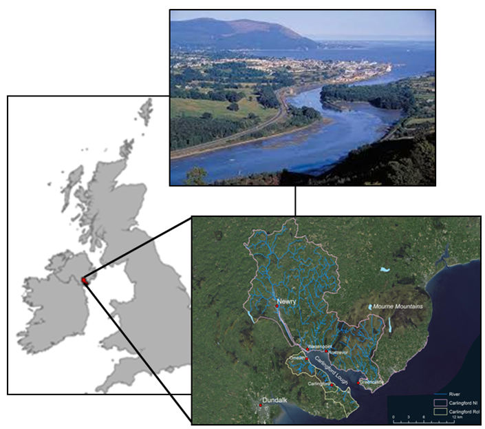
Carlingford Lough
Carlingford Lough is located on the East Coast of Ireland straddling the border between Northern Ireland and the Republic of Ireland. The Lough is a coastal embayment extending 16.5 km into the Irish Sea. It is surrounded by mountains, on its northern shore by the Mourne Mountains in County Down in Northern Ireland, and on its southern shore by the Cooley Mountains in County Louth in the Republic of Ireland. Inflowing catchments drain an area of 470 km2, with the majority lying within Northern Ireland (426 km2) and associated with the Newry, Clanrye, Camlough, Kilbroney and Whitewater rivers.
CLIMATE
The climate in Carlingford catchment is temperate, with an average of temperature of 9°C, with annual rainfall between 800-1000 mm. The area is underlain by a combination of metamorphosed shale and sandstones and igneous granites and as such aquifer productivity is low. Soil cover in the lower elevation areas of the catchment is primarily of glacial origin, with gleys, brown earths, podsols and ranker soil types present. In upland areas soils are primarily humic rankers and mineral gleys.
The largest settlement (pop. 30000 in 2011) is the city of Newry (Northern Ireland) on the banks of the Clanrye river and Newry canal, with other towns along the northern shore at Warrenpoint, Rostrevor and Greencastle in County Down (Northern Ireland). On the southern shore, in county Louth (Republic of Ireland), the towns of Greenore, Carlingford and Omeath are the main urban centres.
The study area incorporates terrestrial, riverine and estuarine ecosystems.
In the terrestrial component, land-use along the Lough shores, is a mixture of forest, rough and improved grazing and small areas of agricultural land. The wider catchment is dominated by a mixture of intensive pasture and arable land, natural grassland, moors and heathland.
The land use of the Carlingford Catchment

HYDROGRAPHY AND RIVER ESTUARIES FEATURES
Water quality has been shown to be poor within the catchment with 21 river sections, failing primarily due to agricultural and urban pollution and sediment loads.
In terms of hydrology, the Newry river is the major freshwater source to the Lough with a flow rate that can vary from 1 m3/s in summer to 9 m3/s in winter. Surface water quality in the catchment, based on WFD status assessments of 21 river sections, is impacted with 95% of waterbodies failing to achieve good status. Groundwater status, assessed based on two monitoring points, is good.
Water chemistry is a cause for failure in many rivers with high phosphorus levels in many rivers attributed to diffuse loads from agricultural sources, drainage from septic tanks, surface runoff and direct drainage. Point sources of nutrient enrichment include estuarine and coastal sewage treatment works and industrial sources. In addition to water chemistry, many failures have been attributed to suppressed invertebrate populations and morphological alterations, including sediment. Atmospheric deposition of nutrients may be significant, particularly with respect to nitrogen. Locally significant nutrient concentrations may also be released from sediments, as end-products from biological and chemical pathways.
In the estuarine component, the Lough is a coastal embayment, extending 16.5 km in a northwest – southeast direction from the Clanrye or Newry river to the Irish Sea. In common with the rest of the Irish coast, tides in the study area are regular and semi-diurnal. Historical records measured at Greenore show that the maximum tidal range is approximately 5.5 m in spring tide and about 1.8 m in neap tide. Variations of the absolute water level as a result of meteorological conditions can however occur adjacent to the shoreline and differences of up to 0.5 m in water level from the tidal predictions are not uncommon.
The upper reaches of the Lough are extremely narrow due to land claim occurring south of Newry. Fine muddy sand beds dominate these areas, while the substratum at the entrance of Carlingford Lough is mostly boulder and cobbles, mixed with patches of bedrock. The sediments in the centre of the Lough are widely varied.
GENERAL TOPOGRAPHY
With a total area of 50 km2, the Lough is generally shallow with an average depth between 2 and 10 m. A narrow channel runs along the centre of the Lough can be as deep as 25 m (it has a maximum depth of 36 m) and width of 4 km, a total coastline of 63 km. It contains 15 km2 of intertidal area.
Siltation in the Narrow Water area (between Newry and Warrenpoint) due to the development of Newry and Warrenpoint urban areas, combined with overfishing, led to the collapse of the native oyster fishery in the early 20th Century, (Ostrea edulis).
Furthermore, a number of invasive species have become established, including Canadian Pondweed (Elodea Canadensis), giant hogweed (Heracleum mantegazzianum), Japanese knotweed (Fallopia japonica) and Himalayan Balsam (Impatiens glandulifera).
Carlingford Lough is host to aquatic estuarine fauna of considerable interest including extensive beds of sea-pens (Virgularia mirabilis) at the mouth of the Lough, sand and rock reefs in the central section and fast-water communities near the mouth. A number of noteworthy marine species can be found, some of which are warm-water species which are only found in this location within Northern Ireland. Towards the mouth of the Lough, there are small areas of saltmarsh between Carlingford and Greenore, and at Mill Bay where the White Water River flows into the Lough. Towards the land, there is a transition in the vegetation from saltmarsh to fen and in certain areas, the saltmarsh is showing symptoms of erosion.
The Lough supports an internationally important population of wintering light-bellied brent geese (Branta bernicla hrota), and nationally important populations of eight species of wintering waterfowl. Green Island, in the lower reaches of the Lough, supports important breeding populations of terns. A small population of common seals breed within the Lough, and grey seals feed within the outer parts of the Lough.
The lough supports a wide variety of aquaculture and fishing interests including the cultivation of oysters, mussels, clams, lobsters and crabs, in addition to hosting a port with requirements for dredging, and recreational activities on both shores.
The catchment supports many human activities:
– Agriculture;
– Fisheries (commercial and recreational);
– Aquaculture and cultivation of oysters, mussels, clams, lobsters and crabs within the Lough itself;
– Fishing throughout the catchment;
– Recreation – on both shores of the lough, Slieve Gullion, mountain biking , events;
– Transport (Ports within the Lough) – in addition to hosting a port with requirements for dredging, and recreational activities on both shores;
– Forestry.
The importance of Carlingford Lough and the need for environmental management is demonstrated by its protected status. Much of the northern foreshore has been designated as a Special Protection Area (SPA) since 1998 for breeding Sandwich and Common Terns and overwintering (non- breeding) Light Bellied Geese.
This area is exclusively terrestrial habitat and consists principally of inter-tidal mudflats and saltmarsh on Carlingford Lough’s northern shore and includes the offshore islands of Green Island and Blockhouse and associated islets in the area.
In 2016, an 3.23km2 area of the northern shore of the inner part of the Lough was designated as an MCZ as it supports the habitat Philine aperta (White lobe shell) and Virgularia mirabilis (Sea-pen) in soft stable infralittoral mud.
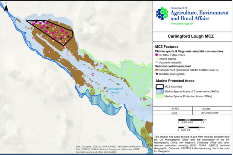
Figure 2 – Location of the boundary of Carlingford Lough MCZ. Source: Conservation Objectives and Potential Management Options, Agriculture, Environment and Rural Affairs.
Furthermore, an expansion of the SPA to the ‘mid-line’ of the Lough has been proposed which would include a marine area of the Irish Sea off the County Down coast. This will recognise the contribution made by the wider coastal and marine area to the needs of the birds. See figure 2.
Carlingford Lough also contains an Area of Special Scientific Interest (ASSI), an Area of Outstanding Natural Beauty (AONB) and a RAMSAR site. The areas of Carlingford Lough on the southern side of the dredged channel have been designated as a Special Area of Conservation (SAC) for the Annex I habitats Annual vegetation of drift lines and Perennial vegetation of stony banks, a SPA for overwinter (non- breeding) Light Bellied Brent Geese and wetlands and a proposed Natural Heritage Area.
Copyright © 2026 | WordPress Theme by MH Themes