
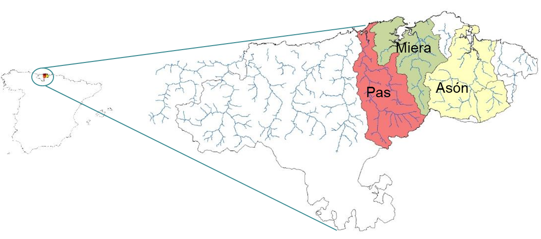
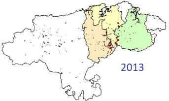
The study case encompasses three river basins located in Northern Spain: Pas, Miera and Asón, incorporating the terrestrial, riverine and estuarine areas. All of them are Atlantic catchments, draining into the Cantabrian Sea with a total drainage surface of 1737 km2.
Administratively, more than 90% of the area belongs to Cantabria (only a small part of the oriental Asón basin is enclosed into the Basque Country). Furthermore, the watershed line in the south of the region marks the administrative border with the Castilla y León Autonomous Community.
Geographically, the three basins are enclosed in the oriental part of the Cantabrian Cordillera. This Cordillera runs from west (Galicia) to east (Basque Country) parallel to the Atlantic Ocean coast, showing in this area lower altitude than in the rest of the mountain range: while the highest peak in the Cantabrian Cordillera reaches 2648 meters (Torrecerredo), the highest peaks in this area have an average altitude ranging between 1300-1700 meters. The mountainous relief and the coastal location of this region define its climatic conditions and the morphologic characteristics of its rivers.

CLIMATE
Climate in the area is temperate hyper-oceanic, defined principally by soft temperatures along the year and abundant humidity, both in precipitation and fog. The average annual precipitation is about 1200mm, although in the upper part of the Pas and Miera catchments the precipitation reaches 2600mm, being the area that receives most rainfall in the entire Cantabrian region.
Rainfall is regularly distributed throughout the year with winter and spring maxima. Storms can occur at any time and snow is common from late autumn to early spring in the mountains. In fact, the upper parts of these basins reach bigger depths of snow than other areas in the Cantabrian Cordillera comparatively higher.
The average annual temperature is 14°C and, although it descends in the upper areas, the relatively low altitudes and the proximity to the sea buffer temperature decrease. Frosts are rare in the coast and internal valleys.
Another relevant climatic phenomenon is the southern wind (Foehn effect). It is frequent in autumn, winter and spring and it is characterized by drastic reductions in humidity and large temperature increases, even reaching 30°C in winter. It usually triggers episodes of snow melting (influencing the hydrological dynamics) and it is used by people to do a particular use of fires explained in greater detail in the “Socioeconomic environment” section.
GENERAL TOPOGRAPHY
In relation to topography, three different morphology zones can be differentiated in the catchments: coastal area in the lower parts, middle internal valleys and mountain range in the upper lands.
COASTAL LOWER PARTS
This area is characterized by the presence of old abrasion marine platforms elevated to various levels and the formation of important estuaries in the mouth of the three catchments.
It is an area of relatively soft slopes in which the combination of rolling hills and some small abrupt karstic massifs break the structure of these lower or more plain formations.
MIDDLE INTERNAL VALLEYS
The central part of the basins is very mountainous, with elevations between 100-1200 meters. This heterogeneous morphology is the result of the interaction among fluvial, glacial and karstic processes.
There are important flood plains in the middle courses of the Pas and Asón rivers.
However, two of the most important features of this area are the manifestations of glaciarism in the valleys of Miera and Asón (very relevant because of the low latitude and altitude) and the karst formations of the central-eastern sector. These last ones stand out at a worldwide scale for a network of caves and galleries of great magnitude.
HIGH MOUNTAIN
The meridional part of the case study has a much more pronounced relief, especially in the central part.
The maximum altitudes exceed 1700 meters, with vertical slopes where the glacial legacy is easily noticeable. Important active slope processes occur in this part of the catchment.
HYDROGRAPHY AND RIVER ESTUARIES FEATURES
The estuaries on this coast are of a single type. The mean tidal range is about 2.8 metres, which determines the development of wide intertidal areas dominated by muddy and sandy sediment. They are all well-mixed estuaries because of the todal mixing. For their part, rivers are short, steep and have a high erosive power.

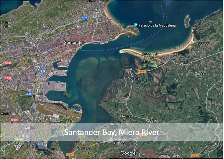

Highly variable valley widths that could be over 1.5 km in most of the middle and upper courses. These characteristics determine that river transports a lot of suspended solids. Solids arrive at the estuaries and they influence its physical and chemical characteristics.
Therefore, the general dynamic of the estuaries is strongly conditioned by the river influence, especially in the stretches of the estuaries near the rivers. Maximum values of turbidity, nitrates and phosphates are detected in these stretches during high-precipitation events.
The three catchments slightly exceed 1700 km2
| Pas | Miera | Asón |
Basin Surface |
650 km2 |
316 km2 |
765 km2 |
Daily Flow | 8.98 m3/s | 5.94 m3/s | 21.85 m3/s |
River length | 57 km | 41 km | 39 km |
Mean annual precipitation | 1300 mm | 1200 mm | 1800 mm |
Pas, Miera and Asón River Basins
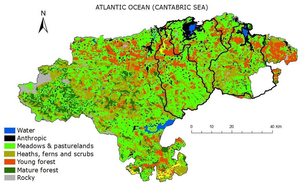
This area presents a notable landscape character. However, it is not equivalent to its general ecological status. In this way, although climax vegetation in the area should be formed by mature states of deciduous forest, largely comprised of a mixture of oaks (Quercus spp.), chestnuts (Corylus avellana) and beeches (Fagus sylvatica),
pasturelands and shrubs cover almost 75% of the catchments
Even so, contrast between the three catchments is considerable, especially with regard to the state of vegetation cover. While vegetation in Pas and Miera catchments has been intensively degraded, Asón catchment preserves more extensive areas of natural forests.
FLORA
The estuaries of the region have some of the richest salt marsh vegetation in the nearest coastal area. It houses important meadows of Zostera marina and Z. noltii, the only two sea grass species present in the local sea environment. Other important species of these coastal areas are (from flooded to terrestrial gradient): Spartina spp., Salicornia sp., Sarcocornia perennis, Halimione portulacoides and Phragmites australis. Furthermore, species like Ammophila arenaria, Eryngium maritimum or Phleum arenarium can be found in the associated dune systems.
The coastal natural forest, below 400 m, is mainly composed of ash (Fraxinus excelsior), lime (Tilia sp.), hazelnut (Corylus avellana), maple (Acer sp.), oak (Quercus robur), poplar (Populus sp.) and, exclusively in limestone areas, holm oak (Quercus ilex). The last is a typical Mediterranean formation, being a bio geographical particularity in the eurosiberian region. Vegetation between 400 to 1100 m includes oak (Quercus robur) dominating on the southern slopes and beech (Fagus sylvatica) and holly (Ilex aquifolium) on the northern slopes. In karst areas, Quercus ilex and Mediterranean shrublands dominate (where the soil is thinner and permeability high). Higher in the catchment (1100 to 1700 m) vegetation is dominated by birch (Betula sp.), heath (Genista sp., Erica sp. and Ulex sp.) and mountain grassland.
However, this vegetation pattern has been highly modified by human activity. Currently, eucalyptus plantations (Eucalyptus globulus) and pastures dominate the coastal area. In inland areas, pastures and shrublands constitute one of the most extensive ecosystems. This biotope has replaced the autochthonous forest by means of afforestation and the use of fire. It is used as food for cattle and horses under extensive exploitation. Ulex europaeus, Erica tetralix, Pteridium aquilinum and Carex asturica dominate in these zones. Productive plantations of Pinus radiate could also be found between 350-800 m.
The riparian zone is dominated by oceanic alder groves (Alnus glutinosa) from almost sea level up to 700 meters and Salix atrocinerea, which replace alder groves when they deteriorate, soils are not deep enough or there are large flow fluctuations. Higher in altitude, ashes (Fraxinus excelsior) or hazelnuts (Corylus avellana) commonly dominate riparian forest, while in steep valleys and uplands, beeches (Fagus sylvatica), oaks (Quercus robur) and mixed Atlantic forest predominate. In modified river banks for flood protection or where agriculture and cattle activities are intensive, riparian vegetation is usually dominated by bramble (Rubus sp.), rose (Rosa sp.), hawthorn (Crataegus monogyna), blackthorn (Prunus spinosa) or even pasture.
FAUNA
In relation to the terrestrial fauna, the strong landscape transformation in the area negatively affects the maintenance of relevant vertebrate populations.
It is noteworthy to stress the presence of some dispersed population of wolves (Canis lupus) in the Pas river catchment, and also the most oriental population of chamois (Rupicapra rupicabra) in the Cantabrian Cordillera and a coastal colony of vultures (Gyps fulvus). Bats are another remarkable group, with 7 species of communitarian interest present in the area (Rhinolophus hipposideros, Rhinolophus ferrumequinum, Rhinolophus Euryale, Myotis,
blythii, Barbastella barbastellus, Miniopterus schreibersii, Myotis emarginatus and Myotis myotis). However, regarding shorebirds Marismas de Santoña is labeled as a very important wetland for several hibernating populations. It provides refuge to around 20,000 waterbirds in some periods. It is also important to note that in the Miera estuary there is one of the largest and more productive areas of molluscs in the Cantabria region.
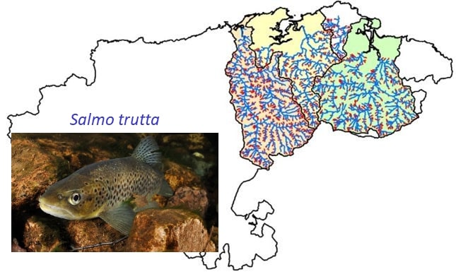
At the fluvial level, the Pas and Asón rivers maintain a small population of Atlantic salmon (Salmo salar) in the southern most extent of the species range, although the fish has a threatened status.
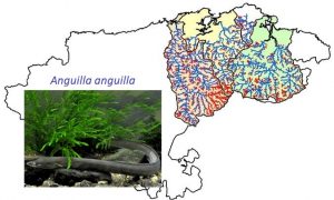
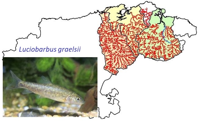
Other species in the case study include brown trout (Salmo trutta), minnow (Phoxinus bigerri) with allis shad (Alosa Alosa), Ebro barbel (Luciobarbus graellsii), para-chondostroma (Parachondrostoma miegii) found in the lower parts of the catchments. Other estuarine fish species that enter the fluvial freshwater habitat are European flounder (Platichthys flesus) and thick lip grey mullet (Chelon labrosus). The otter (Lutra lutra) and the desman (Galemys pyrenaicus) are the most representative mammals of these rivers.
The recovery of the otter in the area has been recorded by the census carried out during the last years (it had suffered a strong decline since the middle of the XX century). Regarding desman, the general lack of information about it prevents us from doing an accurate assessment about the state of their populations. On the other hand, according to the regional trend, the populations of amphibians (Salamandra salamandra, Lissotriton helveticus, Bufo spinosus…) have suffered a marked decline during the last years. Presence of other amphibian species such as the webbed newt, red frog, midwife toad, common salamander, etc., has also being reported in the area.
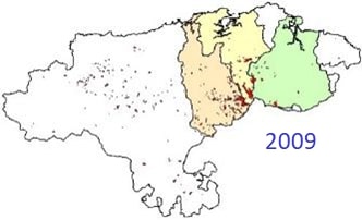
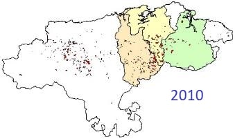
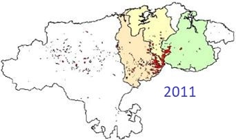
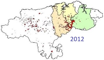
FISH DISTRIBUTIONS
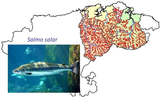
UBIQUITOUS SPECIES
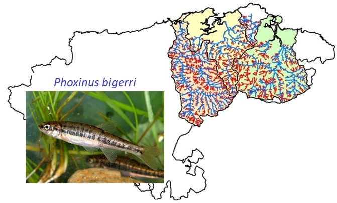
RARE SPECIES (CIPRINIDS)

The first evidences of human settlements in the area are from the upper Paleolithic (40,000–10,000 ybp), indicated by cave paintings from Monte Castillo. Beginning in the 16th century, population densities increased along with numerous land use modifications. Human population density rapidly increased during the 17th and 18th centuries in the main villages of the catchment with a concurrent increase in pasture land for cattle. During this period forests were cleared for pasture but also to supply fire wood for the iron smelting industry. Ten million of trees were cut to manufacture armament in the Royal Artillery Factory in La Cavada during these centuries.
Ten million of trees were cut during 16th -18th centuries to manufacture armament

Traditionally, the inland valleys of these areas have been characterised by a particular way of life called as “La muda”. It is a system of semi-transhumance in which entire families move seasonally between the population centers of the bottom of the valleys and their independent stone-cabins in the mountain pastures. This traditional use of mountain areas for the development of bovine cattle has had a strong impact over the configuration of the landscape and the character of the people. Thus, it is constituted by a mosaic of crops and pastures in the valley bottoms where villages are located, small patches of native forest in mid-slope level and slopes facing north, and small-medium expanses of pastures with a stone-cabin, limited by stone walls, located in upper zones.
The use of mountain areas for the development of bovine cattle. Mountain cabins for “La muda”

Currently, human population in the catchments approximately has reached 70,000 inhabitants, although half of the population is concentrated near the river mouth (Santoña, Laredo, Oruña and Arce…). There are also important population entities for the region in the bottom of most open valleys (Liérganes, Puente Viesgo, Ramales de la Victoria, etc.) Population density is 42 inh/km2, 54 inh/km2 and 60 inh/km2 in Miera, Pas and Asón catchments, respectively. Human density decreases highly as we move into the catchments. The primary sector is predominant in the region, with an important seafood, fishing and bovine (semi-intensive) industry. In this way, although “La muda” has disappeared, the use of fire to ensure the maintenance of pastures is still a common practice in the whole area (especially the days of South wind). In recent years, there has been an increase in the tourism sector, with active plans to promote the ethnographic and natural value of these peculiar valleys.

The three estuaries of the study area have a wide range of pressures coming from numerous human activities. Some of the major ones are the presence of artificial structures that sharply restrict tidal flow, urban development’s with large land reclamation, presence of invasive species (e.g. Baccharis halimifolia) as a consequence of changes in hydrodynamic-flood conditions, harbour activities and shellfish fishery and urban/industrial discharges into the water.
Some of these pressures come from upstream river bodies and from upstream land uses, standing out the sediment production in the catchment as a consequence of afforestation and fires. The effects of these catchment processes need to be disentangled in order to improve catchment processes, ensuring biodiversity conservation and maintaining or recovering ES provision.
In the terrestrial component, landscape structure and vegetation patterns represent the legacy from harsh management practices during the last 400 years. After the foundation of the “Royal Artillery Factory” in La Cavada in 1616, the native forests in the oriental extreme of the region of Cantabria were intensively exploited for 160 years in order to obtain wood for naval construction until 1795. These catchments have been kept deforested for stockbreeding since then through the combined use of fire and cattle grazing. Thus, a mixture of shrubs and extensive pastureland dominates the area, being mature forest patches relegated to head water basins and marginal lands in steeper hillslopes.
In the context of Global Change it is widely accepted that forests play an important role in the mitigation effects of global warming and the fixation of carbon, regulation of river discharge and hydrological stability at a catchment scale and providing a wide variety of ecosystem services. These ecological functions cannot be replaced by actual human-made reforestations, which lack multiple steps of ecological succession and have nothing to do with biological, physical and chemical soil properties.
At the riverine level, riverbanks have been extensively modified for flood protection, as well as for developing intensive agriculture and cattle activities. There are around 1500 physical alterations inventoried in the Pas, Miera and Asón river habitats. The most important pressures are those related to human land use and recurrent disturbances such as forest fires and grazing-farming activities. Urbanization and pressures affect the natural hydromorphological condition of water bodies. This has eliminated natural vegetation, increasing the fragmentation of mature forest patches, and, therefore, reducing connectivity and genetic fluxes among populations and isolating and degrading communities (the so-called habitat types of Nature 2000 network). In addition, water abstraction represents another severe hydromorphological pressure affecting the whole study area. The main cities and urbanized areas of the region (i.e. Suances, Torrelavega, Santander, Santoña, Laredo, etc.) take water for human supply from these catchments. Water abstraction reduces river flows, especially in summer, when several river reaches are completely dry. Water abstractions and scarcity is aggravated due to the decreasing recharge of the aquifer associated to the disconnection between river and floodplains.
Regarding water quality, turbidity and the concentration of nitrates and ammonia increases in spring and autumn, as a consequence of catchment run-off processes and the heavily deforestation of the upper catchment. On the other hand, the concentration of point-source pollutants increases in low flow period, because of the lower dilution capacity of rivers and streams, aggravated by the strong water abstraction for water supply. Nonetheless, the construction of several wastewater treatment plants have significantly improved water quality in the last decades. However, in the last years extremely high temperatures have been detected in Pas and Miera rivers, together with a reduction of certain fish species (i.e. salmon and trout).
In general, this situation claims for an integrative and locally-tailored integrated landscape management strategy that could account for global change effects on local economies and also on biodiversity and ecosystem service provisioning. This will help prioritizing public and private local, national and international investments in the area (e.g. forestry, tourism, cattle) that better achieve the common goal of improving biodiversity and ecosystem service delivery, while improving socioeconomic indicators.
POTENTIAL GREEN INFRASTRUCTURE IN THE CASE STUDY
– Reforestation of hillside and riparian forests. The recovery of the forest mass in various parts of the catchments (e.g. steeply sloping areas) would improve the hydrological and soil conservation processes. The riparian forests facilitate connectivity between the different elements of the landscape and they provide relevant protection services against floods. Additionally, this would increase nutrient filtration to the river in this area of so much livestock pressure.
– Rewilding of hillsides. The selection of areas which have been degraded by fires or clearing to support the ecological succession could be a more economical solution to improve the hydrological-ecological functioning of the catchments.
– Reconnection of river to floodplain. Recovering the natural dynamic of certain floodplains would reduce the constraint of the river. Thus, the river would dissipate a greater energy allowing to improve the response to floods downstream.
– Restoration of coastline forests.
– Recuperation of tidal flats in order to recover the hydrodynamic functioning in the estuaries.
– Restoration of dune systems. They suppose an important element of protection against coastal floods.
Copyright © 2026 | WordPress Theme by MH Themes