The case study area is the Paiva River, a tributary of the Douro, situated in northern Portugal (Figure 1), incorporating the terrestrial and riverine areas. The Paiva is a medium-sized water course (approx. 110 km) that drains into the highly regulated Douro and covers an area of 790 km2. Paiva is considered one of the least polluted rivers in Europe. Most of the catchment is subject to a temperate macrobioclimate, however the estuary has a Mediterranean macrobioclimate.
The catchment orography comprises both gentle and very steep slopes, covered with woodland, scrub, agricultural fields and meadows. The mid-section of the Paiva is gorge like with scrubby woodland and pine stands. There is a great species diversity of fauna and flora, as well as species of priority habitats. The vegetation is relatively well preserved and includes alders and willows, it is often bordered by oak woods of roble oaks. It is also a passage area for the Iberian wolf and covers an important area for other species.
The source of the Paiva on the Nave planalto (Serra de Leomil, approx. 1000 m altitude) is situated in the municipality of Moimenta da Beira. It flows through Castelo de Paiva, on the left bank of the river Douro and through the municipalities of Arouca, Castelo de Paiva, Castro Daire, Cinfães, Moimenta de Beira, São Pedro do Sul, Sátão, Sernancelhe, Vila Nova de Paiva and Viseu.
ABIOTIC ENVIRONMENT
Topography
The Paiva catchment topography is characterized by a craggy relief where altitudes vary between 1360 m (at the headwaters) and 40 m (at the river’s mouth). Precipitation is high across the catchment, but is much higher in altitude (2650 mm/yr) than in lowland areas (1240 mm/yr).
Slopes
Precipitation
Temperature
BIOTIC ENVIRONMENT
Flora
The Paiva catchment contains natural and semi-natural habitats listed in Annex B-I of DL No. 49/2005 (Decree transposing the Birds and Habitats Directives into national legislation) and a Site of Community Interest (SCI: PTCON0059). Priority habitats include Galician-Portuguese oak woods (9230 – Quercus robur and Quercus pyrenaica) and Quercus suber oak woods (9330), alder and ash alluvial woods (91EO Alnus glutinosa and Fraxinus excelsior, Alno-Padion, Alnion incanaeSalicon albae). The banks alternate between rocky sections and earth banks with riparian galleries of alder (Alnus glutinosa), ash (Fraxinus excelsior) and willow (Salix spp). The galleries are relatively well conserved and often surrounded on the outside edge by fragments of oak stands (Quercus spp). Botanical diversity is notable, including Anarrhinum longipedicellatum (Habitats Directive), an endemic rosulate plant species with basilar leaves and many cauline leaves and a dark purple blue flower found only in the Paiva and Vouga river basins.
Fauna
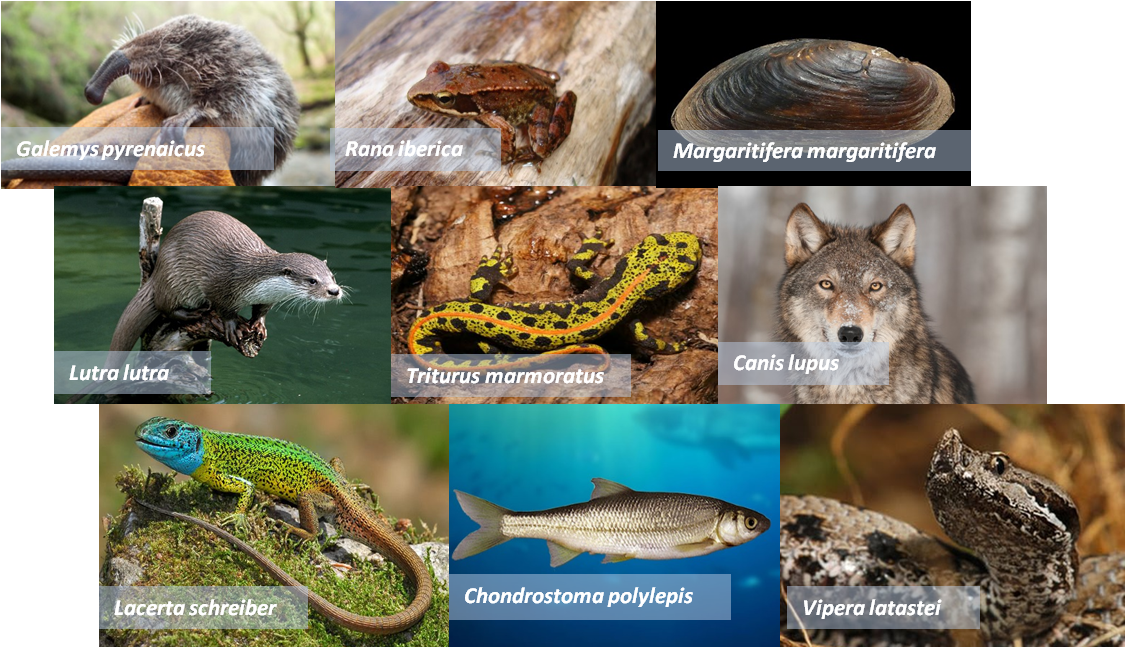
The Paiva is faunistically rich. It contains populations of the water Desman (Galemys pyrenaicus), otter (Lutra lutra), water lizard (Lacerta schreiberi), Lusitanian salamander (Chioglossa lusitanica), Iberian frog (Rana iberica) and red-necked newt (Triturus marmoratus). Some endemic fish species occur – (Chondrostoma polylepis) and rare populations of the endangered freshwater pearl mussel Margaritifera margaritifera can be found.
Measures to improve riparian stands and reintroduce M. margaritifera along selected reaches Paiva have been carried out recently as part of the LIFE “Ecotone” project (LIFE ECOTONE – Gestão de habitats ripícolas para a conservação de invertebrados ameaçados – Management of riparian habitats for the conservation of endangered invertebrates) coordinated by Quercus in collaboration with the Portuguese Environment Agency and the Castro Daire Municipal Council.
Paiva catchment is also an important crossing area for the Iberian wolf (Canis lupus) linking the Montemuro, Freita / Arada and Lapa / Leomil and Mões’ wolf pack ranges. Inaugurated in 2012, the “Paiva Walkway” is an almost 9km long wooden walkway that visitors use to access and admire the biodiversity of the Paiva “riverscape”. This new infrastructure is important in terms of human well-being via contact with nature, a vital ecosystem service and well worth studying in the framework of the ALICE project.
SOCIOECONOMIC ENVIRONMENT
Population density in the Paiva catchment is approximately 46 inhabitants/km2. Principal economic activities in the Paiva are agriculture (particularly livestock), forestry, hunting and fishing. Associated transformation industries are also present in the catchment area. Tourism has growing importance.
The “Passadiços do Paiva”, an hour away from Porto, is a wooden walkway that winds through the less disturbed sections of the river for approximately 8.7 kilometres; another 12 km of walkway is planned in the county of Arouca. This important element of the Arouca Geopark, has become an important source of revenue from tourism and was elected the most innovative tourism project in Europe in the 2016 edition of the World Travel Awards (Leading Tourism Development Project in Europe).
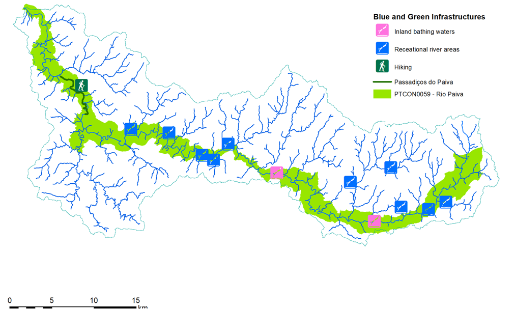
Blue and Green Infrastructures
Soil Use
Potencial problems in the paiva
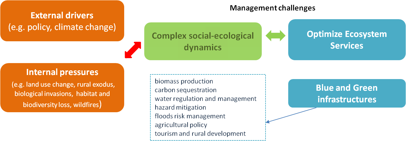
The water quality of the River Paiva is considered one of the best in Europe and the catchment has obvious conservation value. However, the Paiva does suffer from pressures related to recurrent disturbances and human land use such as forest fires, agricultural activities, urbanization and pressures affecting the natural hydromorphological condition and continuity of water bodies. Noted pressures include the invasion of Acacia, clearance of native vegetation and forests for agriculture and urban development but also to supply the pulp and construction industries. Planting of Eucalyptus monocultures and the spread urban areas of have also altered catchment vegetation and land use patterns. The river itself is also affected by the presence of small and larger hydroelectric installations, weirs, the extraction and washing of gravel and sands for aggregate in the construction industry and organic discharge from over capacitated wastewater treatment plants. Rural areas of the Paiva catchment are also subject to abandonment as the younger members of the rural population move to urban areas for employment.
In the context of Global Change it is widely accepted that forests play an important role in the mitigation effects of global warming and the fixation of carbon, regulation of river discharge and hydrological stability at a catchment scale and providing a wide variety of ecosystem services. These ecological functions cannot be replaced by actual human-made reforestations, which lack multiple steps of ecological succession and have nothing to do with biological, physical and chemical soil properties.
In general, this situation claims for an integrative and locally-tailored territory management strategy that could account for global change effects on local economies, biodiversity and ecosystem service provisioning. This will help prioritizing public and private local, national and international investments in the area (e.g. forestry, tourism, and agriculture) that better achieve the common goal of improving biodiversity and ecosystem service delivery, while improving socioeconomic indicators.
SOLUTIONS: GIC AND GINS IMPLEMENTATION
Potential Green Infrastructure to improve catchment processes, biodiversity and Ecosystem Services (ES) provision
– Reforestation of hillsides and riparian forest.
– Reconnection of river to floodplain.
– Restoration of longitudinal connectivity.
– Improve water quality – e.g. retention of nutrients.
– Habitat improvement for target species such as the freshwater pearl mussel and fish species.