
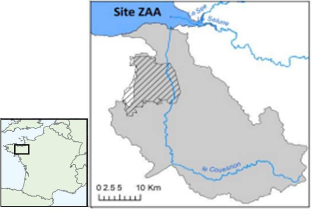
The Case Study includes the Couesnon river catchment located in North-Western France in the Armorican massif.
This is a small river catchment of 1130 km² which discharges into the bay of Mont-Saint-Michel (UNESCO world heritage site).

Mont-Saint-Michel
This catchment is mostly structured by agriculture with mixed grazing pastures in upper stream and polders at the interface with the sea. There is also a short floodplain downstream.
Couesnon estuary comprises with the See and Selune estuaries one of the most important and complex bay worldwide. This bay is submitted to uncommun large range of tide variation leading to various and rare ecosystems.
The Mont-St-Michel bay is recognized through different status such as UNESCO label and different environmental protection.

The Case study includes also the LTER “ZA Armorique” where a small part of the Project will be focused on. The so called ‘Pleine-Fougère’ study site (hatched area) is one of the two observatories of the LTER Armorique site. This study site represents 133 km² on the left side downstream of the river.
It includes entirely two small watersheds that are related to the Couesnon river. These has been monitored since 2010 through automatic sensors.

The study area comprises also the floodplain of the lower Couesnon river which encompasses a large variety of wetlands in terms of management and landscape morphology (from bocage wetlands to open large areas).
This floodplain harbours a high biodiversity and has been designated as a Natura 2000 and RAMSAR protected area.
The main characteristics of this site are the occurence of a landscape gradient of bocage density: with an open landscape in the north with low hedgerow density and crops dominated land-use and in the south a higher hedgerow density with more grasslands and semi-natural hábitats. Hedgerows are usually made up of shredded oaks and sometimes pruned chestnut trees and timber oaks, but also chestnut coppice.

Landscape (floodplain) – Open inundated floodplains (From NATURA, 2000)
CLIMATE
Climate is maritime with the average monthly temperature ranging from 17.5 in July to 5◦C in December and mean annual precipitation of 965mm, a third of which occurs from October to December. There are few extreme climatic events such as snow, storms or frost.
GENERAL TOPOGRAPHY
In relation to topography, there are different morphological zones that can be differentiated in the catchments: coastal area in the lower parts with polders, floodplain around the main course with flooded meadows and bocage area in the upper part.
HYDROGRAPHY AND RIVER ESTUARIES FEATURES
The river Couesnon is 115km long. The hydrographic network is dense due to the low soil permeability and the high regional pluviometry. Water velocity in rivers is directly impacted by pluviometry. The low soil permeability and the important rainfalls led to a dense hydrographic network in the area.
This site is underlained by granite to the south and Brioverian schist to the north. It is characterized by a hilly landscape (slopes lower than 7%, maximum height around 100m).
Land is essentially dominated by agricultural practices around mixed and cattle farming with 56% of the surface dedicated to crops, 28% to meadows which correspond to 84% of the SAU. The area close to the estuarine is characterised by polderized land with intensive market gardening.
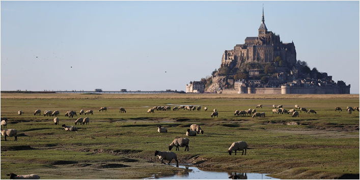
UNESCO world heritage site – Landscape (Mont St Michel Bay) – Intensively grazed salt upmarsh (AOC salted meadow lambs)
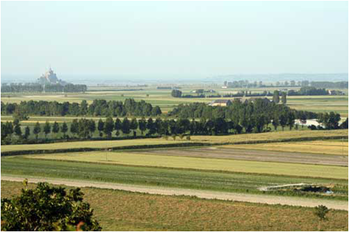
UNESCO world heritage site – Landscape (Mont St Michel Bay) – Intensive crops (vegetables) on polder area
The study area presents agricultural landscapes with crops (maize, cereals –barley, wheat and rapeseed) and grasslands as dominant landscape elements and woodland as secondary habitats. In the lower part, agriculture is dominated by vegetable crops.
The estuaries on this coast are of a single type, characterized by large intertidal surfaces and dominated by the tidal dynamic. Coasts have been polderized in the 19th century conducting to intensive agricultural practices along the coast. In this context crops and cultures of vegetables are dominating the landscape. The Couesnon river has been channelized at the same period. The estuarine is located close to an important touristic site, the Mont St Michel (UNESCO world heritage site). Restoration actions were done close to the estuarine for preventing sedimentation along the Mont St Michel
In the bocage area, crops comprise wheat and maize. Grasslands are temporary sown grasslands with a mixed grazed and mowing management. Hedgerow network is of variable density and connectivity over the area. Wooded areas are mostly post-agricultural woodlands and comprise a mixture of oaks (Quercus sp.), chestnuts (Castanea sativa) and beeches (Fagus sylvatica). Patches are small and isolated in the agricultural matrix.

Floodplain landscape is extremely variable: in the small valleys there is an abandonment of agricultural practices leading to the closure of the wetlands or to the establishment of abandoned habitats.
Since 2005, because environmental protection provisions were added to the Common Agricultural Policy, most streams are lined with grassy strips. Along the Couesnon river, there is a mosaic of landscapes: from large areas with grazing to a mosaic of mowed and grazed with planted wetlands to the establishment of reed beds. This mosaic of habitats are of key interest especially for birds leading to the designation of this site as part of the NATURA2000 network.
One of the wetland has been also included in the regional nature preserve because of its interest in birds preservation, fishes (pike) and the occurrence of a few protected plants (e.g. Luronium natans, Annexe II of Habitat Directive).
The major ecological concerns in these areas include the intensive agricultural practices leading to important nutrient-loads in the rivers, poplars plantation and the invasion of the riverbanks by exotic species.
Regarding water quality, surface and groundwater quality have been monitored for the last 10 years. These long term monitoring programs have allowed the quantification of the average age of groundwater (i.e. 40 years; Kolbe et al. 2016) and the nutrients concentrations which range between 5 and 8 mg N-NO3 L-1 for the nitrate and 0.1 and 0.2 mg P-PO4 L-1 for orthophosphate, values rather low in the regional context, thanks to the preservation of buffering landscape features, i.e. hedgerows, wetlands, permanent meadows (Thomas et al. 2016).

Landscape – Degraded bocage_hedgerows have been removed, mostly crops

Landscape – preserved bocage_hedgerows are dense, well connected, mixed grasslands_crops
The key issue in biodiversity conservation stands in the wet and the coastal areas (NATURA2000 site) with high ecological interests in birds, fishes and plants.
The Couesnon river is colonized by salmons (Salmo salar) which migrates for its reproduction from the sea to the river (IUCN red list), by eels (Anguilla Anguilla) which grow in rivers and reproduce in the sea (annex II CITES). This species has been classified as a threaten to extinction species. The species is present in the whole basins even in the upper parts. Shads and lampreys are also present in the river Couesnon basin where they reproduce after migrating from the sea.
BRIEF HISTORY ABOUT TERRITORRY OCCUPANCY
The Couesnon river basin comprises 75000 inhabitants with a mean density of 70 hab/m² which corresponds to the mean density of rural areas of Brittany. The coastal part is less density inhabited due to the morphology of the coast. The dominant activity is agriculture with family farms. Mean farm size is around 44ha. Agriculture is essentially around cattle grazing (beef) and dairy production. There are a few battery farms with intensive pork or poultry.
ACTIVITIES LINKED WITH COUESNON RIVER
Recreative activities are linked with the Couesnon river with fishing, canoe kayak and hiking. In the coastal part, there is a strong tourism activity with the Mont St Michel, UNESCO site, with more than 3 millions of visitors every year. In 2005 there has been a very important project for restoring the sea appearance of the Mont.
There is also a fishing activity linked with mussels and shrimps harvesting. Hunting activity is also done in the bay due to its important harboring role during winter for many species of migratory ducks and (more than 50000 individuals during winter)
There is no swimming area. Agriculture is also done especially on the salt marshes of the Bay focused on sheep grazing (around 12000 sheeps). This activity shapes strongly the vegetation cover.
Landscape has strongly evolved especially since 1970s through the changes in agricultural policies meanwhile the decline of numbers of farmers involved an increase of farms’ size. This recent evolution is characterized by the removal of hedgerows to widen the fields, the increase of maize areas at the expense of permanent grasslands as well as an abandonment of unfavorable lands often located in riparian areas that are evolving to woodlands. This dynamics is however less pronounced in the southernmost part of the study site.
Major ecological concerns include the impact of intensive agricultural practices on all functions of the ecosystems: nitrogen and pesticides inputs in the ecosystems, loss of biodiversity, loss of species beneficial to agriculture (e.g. pollinators, parasitoides, etc).
In general, this situation claims for an integrative and locally-tailored territory management strategy that could account for global change effects on local economies and also on biodiversity and ecosystem service provisioning. This will help prioritizing public and private local, national and international investments in the area (p.e. tourism, cattle) that better achieve the common goal of improving biodiversity and ecosystem service delivery, while improving socioeconomic indicators.
Potential of Blue and Green Infrastructure Networks in the case study:
– Replantation of hedgerows. Due to water quality issue, there is a strong involvement at the regional scale in a program of replantation of hedgerows to limit soil erosion and nitrate leaching;
– Reconnection of river to floodplain. The Couesnon river comprises currently 80 hydraulic dams limiting the connection of the river. Most of them are mills. There are different restoration actions to get rid of these dams or set up;
– Reincluding permanent grasslands in landscapes;
– Lowering the agricultural pressure in the territories in order to limit nitrogen loads in water.
Copyright © 2026 | WordPress Theme by MH Themes